Flood Control Project
Client: Metropolitan Water Reclamation District of Greater Chicago (MWRD)
Location: Village of Robbins, Illinois
The Village of Robbins is a historically important south suburb of Chicago. Located near the mouth of Midlothian Creek at the downstream end of the watershed tributary to the Little Cal River, the Village has experienced increasing flood events in terms of both intensity and frequency. The Village was identified as a high priority through the MWRD’s Detailed Watershed Plan for the Little Cal River and Donohue was selected to evaluate potential options. Up to 140 acres of the Village were at risk of flooding. In addition, a major state road, Kedzie Avenue, is forced to shut down at least once a year due to water on the pavement.
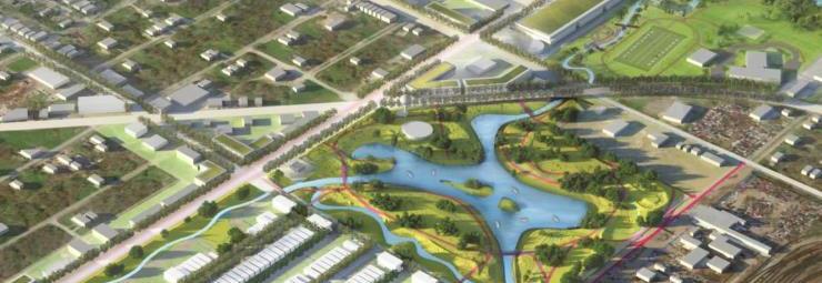
Donohue evaluated a range of potential solutions. The Village preferred to avoid more traditional dry-bottom, isolated detention. Recognizing a unique opportunity, the District, supported by the Donohue team, engaged a broad range of regional governmental and non-governmental agencies to create a solution that integrates the flood control project into the Village’s long-term plans and goals for redevelopment and capacity building. Working closely with the Village, the project team developed a flood control plan that integrated flood control improvements with a community open space/park, a future transit oriented development (TOD) and redevelopment of a former industrial area for job creation.
The final alternative includes detention, diversion to the Cal-Sag Channel, berming, streambank improvements, and green infrastructure for local drainage mitigation. A naturalized wetland park will provide approximately 8 ac-ft of detention storage for the 100-year event, and the diversion channel will convey 383 cfs during the 100-year event, helping to reduce high flows in downstream Midlothian Creek. Amenities include walking trails, vehicle access drives, and a kayak launch. The project requires utility relocation, new storm sewer for roadway drainage, and three 54-inch conduits micro-tunneled beneath an existing roadway. Future community amenities include a playground, natural amphitheater, athletic fields, and event facility.
The project will be constructed in multiple phases to facilitate a faster construction schedule and to align with available grant funding. Following project completion, a Letter of Map Revision will be produced to remove almost 100 structures from flood hazard areas.